
Gransha topographic map
Interactive map
Click on the map to display elevation.
About this map
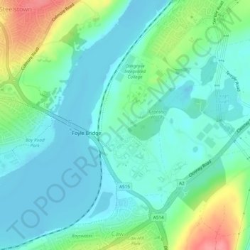
Name: Gransha topographic map, elevation, terrain.
Average elevation: 72 ft
Minimum elevation: -7 ft
Maximum elevation: 272 ft
Other topographic maps
Click on a map to view its topography, its elevation and its terrain.
Altnagelvin
United Kingdom > Northern Ireland > Londonderry/Derry
Altnagelvin, Londonderry/Derry, County Londonderry, Northern Ireland, United Kingdom
Average elevation: 220 ft
Clooney
United Kingdom > Northern Ireland > Londonderry/Derry
Clooney, Londonderry/Derry, County Londonderry, Northern Ireland, United Kingdom
Average elevation: 128 ft
Glack
United Kingdom > Northern Ireland > Londonderry/Derry
Glack, Londonderry/Derry, County Londonderry, Northern Ireland, United Kingdom
Average elevation: 659 ft
Coshquin
United Kingdom > Northern Ireland > Londonderry/Derry
Coshquin, Londonderry/Derry, County Londonderry, Northern Ireland, United Kingdom
Average elevation: 299 ft
Binevenagh
United Kingdom > Northern Ireland > Londonderry/Derry
Binevenagh, Londonderry/Derry, County Londonderry, Northern Ireland, BT49 0JB, United Kingdom
Average elevation: 807 ft