
Ceánuri topographic map
Interactive map
Click on the map to display elevation.
About this map
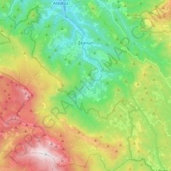
Name: Ceánuri topographic map, elevation, terrain.
Location: Ceánuri, Arratia-Nervión, Vizcaya, País Vasco, 48148, España (43.02392 -2.80379 43.12313 -2.68382)
Average elevation: 2,077 ft
Minimum elevation: 430 ft
Maximum elevation: 4,849 ft
Other topographic maps
Click on a map to view its topography, its elevation and its terrain.
Gorbea
España > País Vasco > Ceánuri
Gorbea, Zuya, Estribaciones del Gorbea, Álava, País Vasco, España
Average elevation: 3,901 ft
Urkiaga
España > País Vasco > Ceánuri
Urkiaga, Ceánuri, Vizcaya, País Vasco, 48148, España
Average elevation: 896 ft
Humedal Saldropo
España > País Vasco > Ceánuri
Humedal Saldropo, Ceánuri, Vizcaya, País Vasco, 48148, España
Average elevation: 2,031 ft