
Paxtang topographic map
Click on the map to display elevation.
About this map
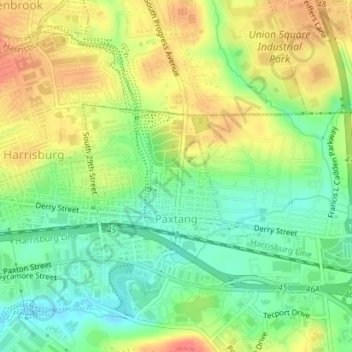
Name: Paxtang topographic map, elevation, terrain.
Location: Paxtang, Dauphin County, Pennsylvania, United States (40.25671 -76.84141 40.26776 -76.82342)
Average elevation: 427 ft
Minimum elevation: 335 ft
Maximum elevation: 531 ft
Dauphin County trails, hiking, mountain biking, running and outdoor activities
Other topographic maps
Click on a map to view its topography, its elevation and its terrain.
Singersville
United States > Pennsylvania > Dauphin County > Middle Paxton Township
Average elevation: 614 ft
Rockville
United States > Pennsylvania > Dauphin County > Susquehanna Township
Average elevation: 463 ft
Shellsville
United States > Pennsylvania > Dauphin County > East Hanover Township
Average elevation: 476 ft
Manada Gap
United States > Pennsylvania > Dauphin County > East Hanover Township
Average elevation: 666 ft
Montrose Park
United States > Pennsylvania > Dauphin County > Susquehanna Township
Average elevation: 344 ft
Piketown
United States > Pennsylvania > Dauphin County > West Hanover Township
Average elevation: 640 ft
Powells Valley
United States > Pennsylvania > Dauphin County > Halifax Township
Average elevation: 587 ft
Hanoverdale
United States > Pennsylvania > Dauphin County > West Hanover Township
Average elevation: 469 ft
Heckton
United States > Pennsylvania > Dauphin County > Middle Paxton Township
Average elevation: 509 ft
Hoernerstown
United States > Pennsylvania > Dauphin County > South Hanover Township
Average elevation: 433 ft
Killinger
United States > Pennsylvania > Dauphin County > Upper Paxton Township
Average elevation: 577 ft
Grantville
United States > Pennsylvania > Dauphin County > East Hanover Township
Average elevation: 469 ft
Union Deposit
United States > Pennsylvania > Dauphin County > South Hanover Township
Average elevation: 410 ft
Wiconisco
United States > Pennsylvania > Dauphin County > Wiconisco Township
Average elevation: 1,083 ft
Bachmanville
United States > Pennsylvania > Dauphin County > Conewago Township
Average elevation: 541 ft
Beaufort Farms
United States > Pennsylvania > Dauphin County > Susquehanna Township
Average elevation: 430 ft
Carsonville
United States > Pennsylvania > Dauphin County > Jefferson Township
Average elevation: 886 ft
Edgemont
United States > Pennsylvania > Dauphin County > Susquehanna Township
Average elevation: 453 ft
Lenkerville
United States > Pennsylvania > Dauphin County > Upper Paxton Township
Average elevation: 512 ft
Locust Lane Gardens
United States > Pennsylvania > Dauphin County > Colonial Park > Locust Lane Gardens
Average elevation: 482 ft
Twin Lakes Park
United States > Pennsylvania > Dauphin County > Twin Lakes Park
Average elevation: 479 ft
Loyalton
United States > Pennsylvania > Dauphin County > Washington Township
Average elevation: 781 ft