Geolocate

Jatani topographic map

Click on the map to display elevation.

Jatani

Jatani is located at 20°05′N 85°25′E / 20.09°N 85.42°E / 20.09; 85.42. It has an average elevation of 36 metres (118 feet).

Wikipedia (CC-BY-SA 3.0)

About this map

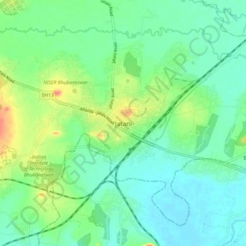
Name: Jatani topographic map, elevation, terrain.

Location: Jatani, Khordha, Odisha, 752050, India (20.12174 85.66524 20.20174 85.74524)

Average elevation: 85 ft

Minimum elevation: 23 ft

Maximum elevation: 240 ft

Other topographic maps

Click on a map to view its topography, its elevation and its terrain.

Jatani

India > Odisha > Jatani

Average elevation: 105 ft

Gear up for your next adventure:

🌡️Portable Weather Meter - Track weather conditions on the trail
🌡️Handheld Weather Meters - Measure wind, temp, and pressure for safe mountain travel
📦Dry Bags Set - Waterproof storage for electronics and clothes
🛶Inflatable Kayak - Portable kayak for rivers, lakes, and expeditions
🚑Emergency Bivvies - Heat-reflective sleeping bags for survival situations

As an Amazon Associate, this site earns from qualifying purchases at no extra cost to you.