
Thank you for supporting this site ❤️
Make a donation
Make a donation
Gear up for your next adventure:
As an Amazon Associate, this site earns from qualifying purchases at no extra cost to you.
Ras Al Khaimah topographic map
Click on the map to display elevation.
Thank you for supporting this site ❤️
Make a donation
Make a donation
Gear up for your next adventure:
As an Amazon Associate, this site earns from qualifying purchases at no extra cost to you.
About this map
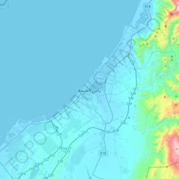
Name: Ras Al Khaimah topographic map, elevation, terrain.
Location: Ras Al Khaimah, Ras al-Khaimah Emirate, United Arab Emirates (25.61377 55.77823 25.93377 56.09823)
Average elevation: 302 ft
Minimum elevation: -36 ft
Maximum elevation: 4,990 ft
Thank you for supporting this site ❤️
Make a donation
Make a donation
Gear up for your next adventure:
As an Amazon Associate, this site earns from qualifying purchases at no extra cost to you.
Other topographic maps
Click on a map to view its topography, its elevation and its terrain.