
Make a donation
Gear up for your next adventure:
As an Amazon Associate, this site earns from qualifying purchases at no extra cost to you.
Ullared topographic map
Click on the map to display elevation.
Make a donation
Gear up for your next adventure:
As an Amazon Associate, this site earns from qualifying purchases at no extra cost to you.
About this map
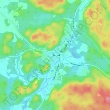
Name: Ullared topographic map, elevation, terrain.
Location: Ullared, Falkenbergs kommun, Halland County, 311 60, Sweden (57.11610 12.69558 57.15610 12.73558)
Average elevation: 318 ft
Minimum elevation: 203 ft
Maximum elevation: 577 ft
Make a donation
Gear up for your next adventure:
As an Amazon Associate, this site earns from qualifying purchases at no extra cost to you.
Other topographic maps
Click on a map to view its topography, its elevation and its terrain.
Make a donation
Gear up for your next adventure:
As an Amazon Associate, this site earns from qualifying purchases at no extra cost to you.
Make a donation
Gear up for your next adventure:
As an Amazon Associate, this site earns from qualifying purchases at no extra cost to you.