
Talsperre Neustadt topographic map
Interactive map
Click on the map to display elevation.
About this map
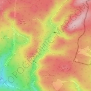
Name: Talsperre Neustadt topographic map, elevation, terrain.
Average elevation: 1,598 ft
Minimum elevation: 1,129 ft
Maximum elevation: 1,870 ft
Other topographic maps
Click on a map to view its topography, its elevation and its terrain.
Neustadt/Harz
Deutschland > Thüringen > Harztor
Neustadt/Harz, Harztor, Landkreis Nordhausen, Thüringen, 99762, Deutschland
Average elevation: 1,129 ft
Weiter Moorkopf
Deutschland > Thüringen > Harztor
Weiter Moorkopf, Harztor, Landkreis Nordhausen, Thüringen, 99762, Deutschland
Average elevation: 1,634 ft
Bielstein
Deutschland > Thüringen > Harztor
Bielstein, Harztor, Landkreis Nordhausen, Thüringen, 99762, Deutschland
Average elevation: 1,365 ft