
Florida topographic map
Interactive map
Click on the map to display elevation.
About this map
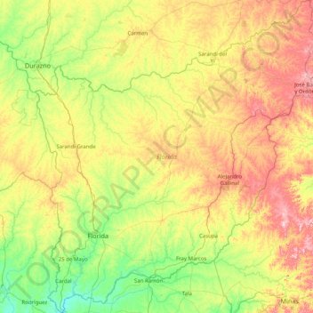
Name: Florida topographic map, elevation, terrain.
Location: Florida, Uruguai (-34.42643 -56.53634 -33.10171 -55.09821)
Average elevation: 417 ft
Minimum elevation: 33 ft
Maximum elevation: 1,247 ft
Other topographic maps
Click on a map to view its topography, its elevation and its terrain.
Sarandí Grande
Uruguai > Florida > Sarandí Grande
Sarandí Grande, Florida, 94100, Uruguai
Average elevation: 453 ft
Fray Marcos
Uruguai > Florida > Fray Marcos
Fray Marcos, Florida, 90601, Uruguai
Average elevation: 246 ft