
Tumoulin State Forest topographic map
Interactive map
Click on the map to display elevation.
About this map
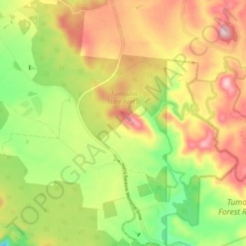
Name: Tumoulin State Forest topographic map, elevation, terrain.
Average elevation: 3,245 ft
Minimum elevation: 2,782 ft
Maximum elevation: 3,724 ft
Other topographic maps
Click on a map to view its topography, its elevation and its terrain.
Ravenshoe
Australia > Queensland > Ravenshoe
Ravenshoe, Tablelands Regional, Queensland, Australia
Average elevation: 3,097 ft
Millstream Falls National Park
Australia > Queensland > Ravenshoe
Millstream Falls National Park, Kennedy Highway, Ravenshoe, Queensland, Australia
Average elevation: 2,831 ft