
Col Sella topographic map
Interactive map
Click on the map to display elevation.
About this map
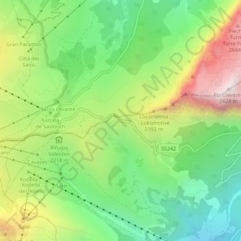
Name: Col Sella topographic map, elevation, terrain.
Average elevation: 7,136 ft
Minimum elevation: 5,771 ft
Maximum elevation: 9,229 ft
Other topographic maps
Click on a map to view its topography, its elevation and its terrain.
Lago di Fedaia
Italie > Trentin-Haut-Adige > Canazei
Lago di Fedaia, SS641, Canazei, Comun General de Fascia, TN, Trentin-Haut-Adige, 32023, Italie
Average elevation: 7,444 ft