
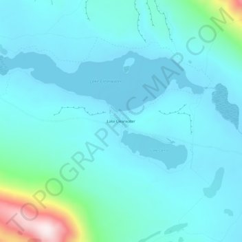
Lake Clearwater topographic map
Interactive map
Click on the map to display elevation.
About this map
Name: Lake Clearwater topographic map, elevation, terrain.
Average elevation: 2,464 ft
Minimum elevation: 2,182 ft
Maximum elevation: 4,288 ft
Other topographic maps
Click on a map to view its topography, its elevation and its terrain.
Ashburton
New Zealand > Canterbury > Ashburton District
Ashburton, Ashburton District, Canterbury, 7700, New Zealand
Average elevation: 325 ft
Ōtūroto / Lake Heron
New Zealand > Canterbury > Ashburton District
Ōtūroto / Lake Heron, Ashburton District, Canterbury, New Zealand
Average elevation: 2,461 ft
Totara Peak
New Zealand > Canterbury > Ashburton District
Totara Peak, Ashburton District, Canterbury, New Zealand
Average elevation: 5,397 ft
Rakaia Gorge lookout
New Zealand > Canterbury > Ashburton District
Rakaia Gorge lookout, Arundel Rakaia Gorge Road, Ashburton District, Canterbury, New Zealand
Average elevation: 1,175 ft
Dromore
New Zealand > Canterbury > Ashburton District
Dromore, Ashburton District, Canterbury, 7772, New Zealand
Average elevation: 404 ft
Methven
New Zealand > Canterbury > Ashburton District
Methven, Ashburton District, Canterbury, 7730, New Zealand
Average elevation: 1,056 ft
Hackthorne
New Zealand > Canterbury > Ashburton District
Hackthorne, Ashburton District, Canterbury, New Zealand
Average elevation: 653 ft
Mayfield
New Zealand > Canterbury > Ashburton District
Mayfield, Ashburton District, Canterbury, 7778, New Zealand
Average elevation: 873 ft
Ashburton Lakes
New Zealand > Canterbury > Ashburton District
Ashburton Lakes, Ashburton District, Canterbury, New Zealand
Average elevation: 2,116 ft
Ruapuna
New Zealand > Canterbury > Ashburton District
Ruapuna, Ashburton District, Canterbury, New Zealand
Average elevation: 991 ft
Mount Somers
New Zealand > Canterbury > Ashburton District
Mount Somers, Ashburton District, Canterbury, New Zealand
Average elevation: 4,006 ft