
Western Cleddau topographic map
Interactive map
Click on the map to display elevation.
About this map
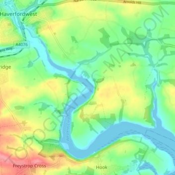
Name: Western Cleddau topographic map, elevation, terrain.
Average elevation: 95 ft
Minimum elevation: -3 ft
Maximum elevation: 266 ft
Other topographic maps
Click on a map to view its topography, its elevation and its terrain.
Grassholm
United Kingdom > Wales > St David's
Grassholm, Marloes and St Brides, Pembrokeshire, Wales, United Kingdom
Average elevation: 0 ft
Skokholm
United Kingdom > Wales > St David's
Skokholm, St David's, Pembrokeshire, Wales, SA62 3BL, United Kingdom
Average elevation: 10 ft
Ramsey Island
United Kingdom > Wales > St David's
Ramsey Island, St David's, Pembrokeshire, Wales, United Kingdom
Average elevation: 46 ft