
Lone Butte topographic map
Click on the map to display elevation.
About this map
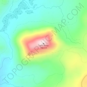
Name: Lone Butte topographic map, elevation, terrain.
Location: Lone Butte, Skamania County, Washington, United States (46.05451 -121.83930 46.05461 -121.83920)
Average elevation: 3,606 ft
Minimum elevation: 3,156 ft
Maximum elevation: 4,642 ft
Skamania County trails, hiking, mountain biking, running and outdoor activities
Other topographic maps
Click on a map to view its topography, its elevation and its terrain.
Gifford Pinchot National Forest
United States > Washington > Skamania County
Gifford Pinchot National Forest is located in a mountainous region approximately between Mount St. Helens to the west, Mount Adams to the east, Mount Rainier National Park to the north, and the Columbia River to the south. This region of Southwest Washington is noted for its complex topography and volcanic…
Average elevation: 2,523 ft
Spirit Lake
United States > Washington > Skamania County
Prior to 1980, Spirit Lake consisted of two arms that occupied what had been the valleys of the North Fork Toutle River and a tributary. About 4,000 years ago, these valleys were blocked by lahars and pyroclastic flow deposits from Mount St. Helens to form the pre-1980 Spirit Lake. The longest branch of Spirit…
Average elevation: 3,753 ft