
Oberschöllenbach topographic map
Interactive map
Click on the map to display elevation.
About this map
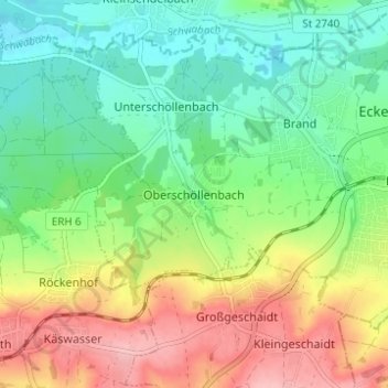
Name: Oberschöllenbach topographic map, elevation, terrain.
Average elevation: 1,145 ft
Minimum elevation: 981 ft
Maximum elevation: 1,404 ft
Other topographic maps
Click on a map to view its topography, its elevation and its terrain.
Eckenhaid
Deutschland > Bayern > Landkreis Erlangen-Höchstadt > Eckental
Eckenhaid, Eckental, Landkreis Erlangen-Höchstadt, Bayern, 90542, Deutschland
Average elevation: 1,165 ft
Forth
Deutschland > Bayern > Landkreis Erlangen-Höchstadt > Eckental
Forth, Eckental, Landkreis Erlangen-Höchstadt, Bayern, 90542, Deutschland
Average elevation: 1,119 ft