Geolocate

Suamico topographic map

Click on the map to display elevation.

About this map

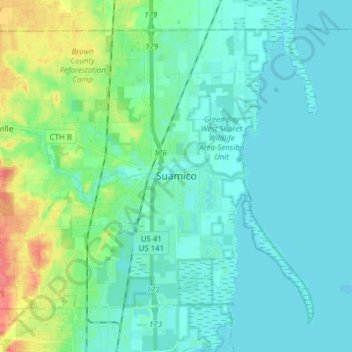
Name: Suamico topographic map, elevation, terrain.

Location: Suamico, Brown County, Wisconsin, 54173, United States (44.58589 -88.13141 44.67764 -87.97743)

Average elevation: 614 ft

Minimum elevation: 574 ft

Maximum elevation: 758 ft

Brown County trails, hiking, mountain biking, running and outdoor activities

Other topographic maps

Click on a map to view its topography, its elevation and its terrain.

Greenleaf

United States > Wisconsin > Brown County

Average elevation: 741 ft

Anston

United States > Wisconsin > Brown County

Average elevation: 738 ft

Champion

United States > Wisconsin > Brown County

Average elevation: 771 ft

New Franken

United States > Wisconsin > Brown County

Average elevation: 801 ft

Bellevue

United States > Wisconsin > Brown County > Bellevue > Bellevue

Average elevation: 692 ft

Holland

United States > Wisconsin > Brown County

Average elevation: 771 ft

Gear up for your next adventure:

🧦Hiking Socks - Comfortable socks to prevent blisters on long hikes
📶Satellite Messenger - Communication device off‑grid
Backpacking Tents - Weight-optimized shelters for multi-day topographic surveys
🧢Outdoor Hiking Hat - Sun protection hat for outdoor explorers
🌲Outdoor Survival Books - Best books on survival skills

As an Amazon Associate, this site earns from qualifying purchases at no extra cost to you.