
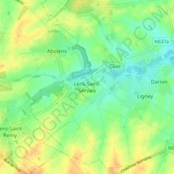
Lens-Saint-Servais topographic map
Interactive map
Click on the map to display elevation.
About this map
Name: Lens-Saint-Servais topographic map, elevation, terrain.
Average elevation: 443 ft
Minimum elevation: 394 ft
Maximum elevation: 505 ft
Other topographic maps
Click on a map to view its topography, its elevation and its terrain.
Bettincourt
Belgique > Liège > Waremme > Waremme
Bettincourt, Waremme, Liège, Wallonie, 4300, Belgique
Average elevation: 390 ft
Petit-Hallet
Belgique > Liège > Waremme > Hannut
Petit-Hallet, Hannut, Waremme, Liège, Wallonie, 4280, Belgique
Average elevation: 351 ft
Saint-Georges-sur-Meuse
Saint-Georges-sur-Meuse, Waremme, Liège, Wallonie, 4470, Belgique
Average elevation: 531 ft
Fize-le-Marsal
Belgique > Liège > Waremme > Fize-le-Marsal
Fize-le-Marsal, Crisnée, Waremme, Liège, Wallonie, 4367, Belgique
Average elevation: 430 ft
Voroux-Goreux
Voroux-Goreux, Fexhe-le-Haut-Clocher, Waremme, Liège, Wallonie, 4347, Belgique
Average elevation: 545 ft
Grand-Hallet
Belgique > Liège > Waremme > Hannut
Grand-Hallet, Hannut, Waremme, Liège, Wallonie, 4280, Belgique
Average elevation: 361 ft
Fexhe-le-Haut-Clocher
Fexhe-le-Haut-Clocher, Waremme, Liège, Wallonie, 4347, Belgique
Average elevation: 509 ft
Les Waleffes
Les Waleffes, Faimes, Waremme, Liège, Wallonie, 4317, Belgique
Average elevation: 502 ft