
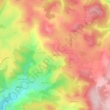
Les Brosses topographic map
Interactive map
Click on the map to display elevation.
About this map
Name: Les Brosses topographic map, elevation, terrain.
Average elevation: 1,667 ft
Minimum elevation: 1,070 ft
Maximum elevation: 2,051 ft
Other topographic maps
Click on a map to view its topography, its elevation and its terrain.
Savault
France > Bourgogne-Franche-Comté > Nièvre > Ouroux-en-Morvan
Savault, Ouroux-en-Morvan, Château-Chinon (Ville), Nièvre, Bourgogne-Franche-Comté, France métropolitaine, 58230, France
Average elevation: 1,686 ft
Savelot
France > Bourgogne-Franche-Comté > Nièvre > Ouroux-en-Morvan > Savelot
Savelot, Ouroux-en-Morvan, Château-Chinon (Ville), Nièvre, Bourgogne-Franche-Comté, France métropolitaine, 58230, France
Average elevation: 1,821 ft
Coeuzon
France > Bourgogne-Franche-Comté > Nièvre > Ouroux-en-Morvan
Coeuzon, Ouroux-en-Morvan, Château-Chinon (Ville), Nièvre, Bourgogne-Franche-Comté, France métropolitaine, 58230, France
Average elevation: 1,850 ft
Le Plessis
France > Bourgogne-Franche-Comté > Nièvre > Ouroux-en-Morvan > Le Plessis
Le Plessis, Ouroux-en-Morvan, Château-Chinon (Ville), Nièvre, Bourgogne-Franche-Comté, France métropolitaine, 58230, France
Average elevation: 1,768 ft
Jallois
France > Bourgogne-Franche-Comté > Nièvre > Ouroux-en-Morvan
Jallois, Ouroux-en-Morvan, Château-Chinon (Ville), Nièvre, Bourgogne-Franche-Comté, France métropolitaine, 58230, France
Average elevation: 1,696 ft