Geolocate

Monte Stella topographic map

Click on the map to display elevation.

About this map

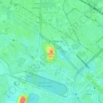
Name: Monte Stella topographic map, elevation, terrain.

Location: Monte Stella, Milan, Lombardy, 20156, Italy (45.49083 9.13443 45.49093 9.13453)

Average elevation: 440 ft

Minimum elevation: 397 ft

Maximum elevation: 564 ft

Other topographic maps

Click on a map to view its topography, its elevation and its terrain.

Barona

Italy > Lombardy > Milan > Milan

Average elevation: 384 ft

Municipio 8 di Milano

Italy > Lombardy > Milan > Milan

Average elevation: 453 ft

Parco Sempione

Italy > Lombardy > Milan > Milan

Average elevation: 433 ft

Municipio 8 di Milano

Italy > Lombardy > Milan > Milan

Average elevation: 453 ft

Gear up for your next adventure:

🔌USB Car Charger - Car charger for on‑the‑go power needs
🛰️Handheld GPS Units - Professional satellite navigators for precise backcountry mapping
🪶Compact Camp Shovel - Folding shovel for campsite tasks
🌐World Map Poster - Decorative world maps with topographic info
☀️Outdoor Sunscreen - High protection sunscreen for outdoor activities

As an Amazon Associate, this site earns from qualifying purchases at no extra cost to you.