
Thank you for supporting this site ❤️
Make a donation
Make a donation
Gear up for your next adventure:
As an Amazon Associate, this site earns from qualifying purchases at no extra cost to you.
Dumalneg topographic map
Click on the map to display elevation.
Thank you for supporting this site ❤️
Make a donation
Make a donation
Gear up for your next adventure:
As an Amazon Associate, this site earns from qualifying purchases at no extra cost to you.
About this map
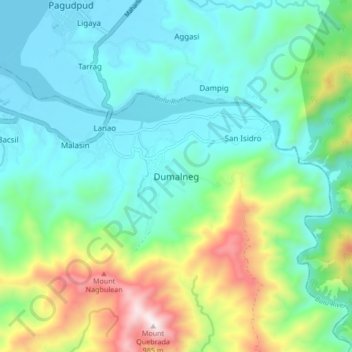
Name: Dumalneg topographic map, elevation, terrain.
Location: Dumalneg, Ilocos Norte, Ilocos Region, 2921, Philippines (18.48039 120.77225 18.56039 120.85225)
Average elevation: 817 ft
Minimum elevation: -3 ft
Maximum elevation: 3,189 ft
Thank you for supporting this site ❤️
Make a donation
Make a donation
Gear up for your next adventure:
As an Amazon Associate, this site earns from qualifying purchases at no extra cost to you.