
Thank you for supporting this site ❤️
Make a donation
Make a donation
Gear up for your next adventure:
As an Amazon Associate, this site earns from qualifying purchases at no extra cost to you.
Frosolone topographic map
Click on the map to display elevation.
Thank you for supporting this site ❤️
Make a donation
Make a donation
Gear up for your next adventure:
As an Amazon Associate, this site earns from qualifying purchases at no extra cost to you.
About this map
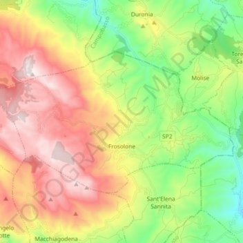
Name: Frosolone topographic map, elevation, terrain.
Location: Frosolone, Isernia, Molise, 86095, Italy (41.58018 14.36946 41.64264 14.51284)
Average elevation: 2,884 ft
Minimum elevation: 1,460 ft
Maximum elevation: 4,636 ft
Thank you for supporting this site ❤️
Make a donation
Make a donation
Gear up for your next adventure:
As an Amazon Associate, this site earns from qualifying purchases at no extra cost to you.