
Irvinestown topographic map
Interactive map
Click on the map to display elevation.
About this map
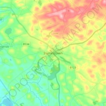
Name: Irvinestown topographic map, elevation, terrain.
Average elevation: 312 ft
Minimum elevation: 135 ft
Maximum elevation: 587 ft
Other topographic maps
Click on a map to view its topography, its elevation and its terrain.
Brookeborough
United Kingdom > Northern Ireland > County Fermanagh
Brookeborough, County Fermanagh, Northern Ireland, BT94 4EZ, United Kingdom
Average elevation: 318 ft
Brattan's Hill
United Kingdom > Northern Ireland > County Fermanagh
Brattan's Hill, Ardunshin, County Fermanagh, Northern Ireland, BT94 4RT, United Kingdom
Average elevation: 259 ft
White Island
United Kingdom > Northern Ireland > County Fermanagh
White Island, County Fermanagh, Ulster, Northern Ireland, United Kingdom
Average elevation: 157 ft
Lough Navar
United Kingdom > Northern Ireland > County Fermanagh
Lough Navar, Barr of Drumbadmeen, County Fermanagh, Ulster, Northern Ireland, United Kingdom
Average elevation: 761 ft
Carr
United Kingdom > Northern Ireland > County Fermanagh
Carr, County Fermanagh, Northern Ireland, United Kingdom
Average elevation: 197 ft
Ederney
United Kingdom > Northern Ireland > County Fermanagh
Ederney, County Fermanagh, Northern Ireland, BT93 0DG, United Kingdom
Average elevation: 299 ft
Tempo
United Kingdom > Northern Ireland > County Fermanagh > Tempo
Tempo, County Fermanagh, Northern Ireland, BT94 3LU, United Kingdom
Average elevation: 417 ft
Bellanaleck
United Kingdom > Northern Ireland > County Fermanagh
Bellanaleck, County Fermanagh, Ulster, Northern Ireland, BT92 2BA, United Kingdom
Average elevation: 177 ft
Belcoo
United Kingdom > Northern Ireland > County Fermanagh
Belcoo, County Fermanagh, Ulster, Northern Ireland, BT93 5FB, United Kingdom
Average elevation: 282 ft
Derrygonnelly
United Kingdom > Northern Ireland > County Fermanagh
Derrygonnelly, County Fermanagh, Ulster, Northern Ireland, BT93 6HW, United Kingdom
Average elevation: 259 ft
Cuilcagh
United Kingdom > Northern Ireland > County Fermanagh
Cuilcagh, Cavan-Belturbet Municipal District, County Cavan, Ireland
Average elevation: 1,549 ft