Geolocate

Prigen topographic map

Click on the map to display elevation.

About this map

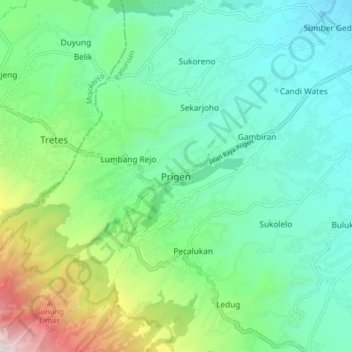
Name: Prigen topographic map, elevation, terrain.

Location: Prigen, Pasuruan, East Java, Java, Indonesia (-7.72055 112.60062 -7.64055 112.68062)

Average elevation: 2,051 ft

Minimum elevation: 515 ft

Maximum elevation: 6,558 ft

Other topographic maps

Click on a map to view its topography, its elevation and its terrain.

Batas Desa Sumberanyar

Indonesia > East Java > Pasuruan

Average elevation: 128 ft

Gear up for your next adventure:

🧭Outdoor Navigation Book - Learn advanced navigation skills
🥾Women's Hiking Boots - Top-rated trail boots with ankle support and superior grip
🧺Microfiber Travel Towels - Compact and fast-drying towels for trail use
🥩Freeze-Dried Meals - Nutritious and lightweight food for remote expeditions
🔭Compact Binoculars - HD vision for scouting terrain and identifying distant landmarks

As an Amazon Associate, this site earns from qualifying purchases at no extra cost to you.