
Mainburg topographic map
Interactive map
Click on the map to display elevation.
About this map
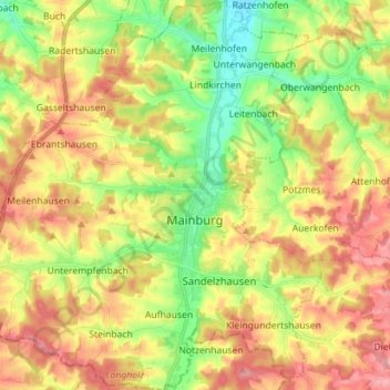
Name: Mainburg topographic map, elevation, terrain.
Location: Mainburg, Landkreis Kelheim, Bavaria, 84048, Germany (48.59977 11.69187 48.69302 11.82806)
Average elevation: 1,496 ft
Minimum elevation: 1,312 ft
Maximum elevation: 1,686 ft
Other topographic maps
Click on a map to view its topography, its elevation and its terrain.
Offenstetten
Germany > Bavaria > Landkreis Kelheim
Offenstetten, Abensberg, Landkreis Kelheim, Bavaria, 93348, Germany
Average elevation: 1,263 ft
Mauern
Germany > Bavaria > Landkreis Kelheim > Neustadt an der Donau
Mauern, Neustadt an der Donau, Landkreis Kelheim, Bavaria, 93333, Germany
Average elevation: 1,158 ft
Kelheim
Germany > Bavaria > Landkreis Kelheim
Kelheim, Landkreis Kelheim, Bavaria, 93309, Germany
Average elevation: 1,388 ft
Paring
Germany > Bavaria > Landkreis Kelheim > Paring
Paring, Langquaid, Langquaid (VGem), Landkreis Kelheim, Bavaria, 84085, Germany
Average elevation: 1,325 ft