
Marine Corps Base Hawaii Kaneohe topographic map
Interactive map
Click on the map to display elevation.
About this map
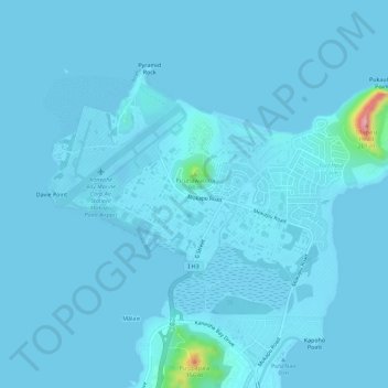
Name: Marine Corps Base Hawaii Kaneohe topographic map, elevation, terrain.
Average elevation: 23 ft
Minimum elevation: -16 ft
Maximum elevation: 650 ft
Other topographic maps
Click on a map to view its topography, its elevation and its terrain.
Kapunahala
United States > Hawaii > Honolulu County > Kaneohe
Kapunahala, Kaneohe, Honolulu County, Hawaii, 96744, United States
Average elevation: 299 ft
Kokokahi
United States > Hawaii > Honolulu County > Kaneohe
Kokokahi, Kaneohe, Honolulu County, Hawaii, 96744, United States
Average elevation: 89 ft
Ho'omaluhia Botanical Garden
United States > Hawaii > Honolulu County > Kaneohe > Keapuka
Ho'omaluhia Botanical Garden, Keapuka, Kaneohe, Honolulu County, Hawaii, 96744, United States
Average elevation: 509 ft