
Thank you for supporting this site ❤️
Make a donation
Make a donation
Gear up for your next adventure:
As an Amazon Associate, this site earns from qualifying purchases at no extra cost to you.
Udange topographic map
Click on the map to display elevation.
Thank you for supporting this site ❤️
Make a donation
Make a donation
Gear up for your next adventure:
As an Amazon Associate, this site earns from qualifying purchases at no extra cost to you.
About this map
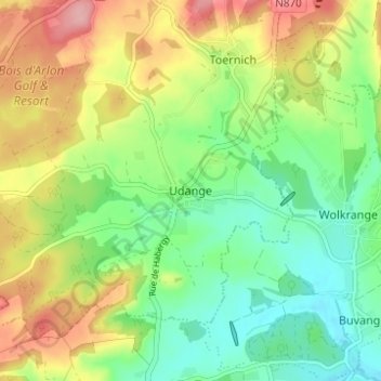
Name: Udange topographic map, elevation, terrain.
Location: Udange, Arlon, Luxembourg, Wallonia, 6700, Belgium (49.61750 5.75264 49.65750 5.79264)
Average elevation: 1,109 ft
Minimum elevation: 938 ft
Maximum elevation: 1,358 ft
Thank you for supporting this site ❤️
Make a donation
Make a donation
Gear up for your next adventure:
As an Amazon Associate, this site earns from qualifying purchases at no extra cost to you.