
Lindis Pass topographic map
Interactive map
Click on the map to display elevation.
About this map
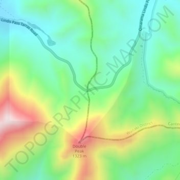
Name: Lindis Pass topographic map, elevation, terrain.
Location: Lindis Pass, Waitaki District, Canterbury, New Zealand (-44.58831 169.64303 -44.58821 169.64313)
Average elevation: 3,317 ft
Minimum elevation: 2,644 ft
Maximum elevation: 4,616 ft
Lindis Pass (Māori: Ōmakō) (elevation 971 m) is located in the South Island of New Zealand. A carpark at the top of the pass provides access to a viewpoint and two short trails to other viewing spots.
Other topographic maps
Click on a map to view its topography, its elevation and its terrain.
Ohau Peak
New Zealand > Canterbury > Waitaki District
Ohau Peak, Waitaki District, Canterbury, New Zealand
Average elevation: 5,095 ft
Waitaki River
New Zealand > Canterbury > Waitaki District
Waitaki River, Waitaki District, Canterbury, New Zealand
Average elevation: 584 ft
Omarama
New Zealand > Canterbury > Waitaki District
Omarama, Waitaki District, Canterbury, 9412, New Zealand
Average elevation: 1,509 ft
Lake Ruataniwha
New Zealand > Canterbury > Waitaki District
Lake Ruataniwha, Waitaki District, Canterbury, New Zealand
Average elevation: 1,611 ft
Kurow
New Zealand > Canterbury > Waitaki District
Kurow, Waitaki District, Canterbury, 9435, New Zealand
Average elevation: 899 ft
Otematata
New Zealand > Canterbury > Waitaki District
Otematata, Waitaki District, Canterbury, New Zealand
Average elevation: 1,125 ft
Otiake River
New Zealand > Canterbury > Waitaki District
Otiake River, Waitaki District, Canterbury, New Zealand
Average elevation: 741 ft