
Aschau im Zillertal topographic map
Interactive map
Click on the map to display elevation.
About this map
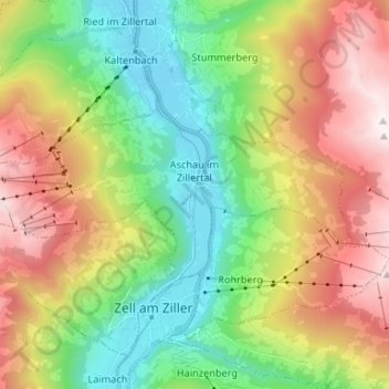
Name: Aschau im Zillertal topographic map, elevation, terrain.
Location: Aschau im Zillertal, Bezirk Schwaz, 6274, Oostenrijk (47.23970 11.81724 47.27977 11.94910)
Average elevation: 4,104 ft
Minimum elevation: 1,795 ft
Maximum elevation: 7,595 ft
Other topographic maps
Click on a map to view its topography, its elevation and its terrain.
Ried im Zillertal
Ried im Zillertal, Bezirk Schwaz, 6273, Oostenrijk
Average elevation: 3,406 ft
Zellbergeben
Oostenrijk > Bezirk Schwaz > Zellberg
Zellbergeben, Zellberg, Bezirk Schwaz, 6277, Oostenrijk
Average elevation: 2,917 ft
Zillertal
Oostenrijk > Bezirk Schwaz > Kaltenbach
Zillertal, Kaltenbach, Bezirk Schwaz, Oostenrijk
Average elevation: 4,918 ft