
Hone Creek topographic map
Interactive map
Click on the map to display elevation.
About this map
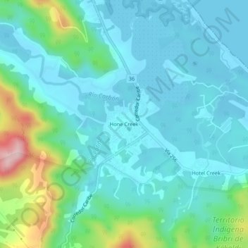
Name: Hone Creek topographic map, elevation, terrain.
Average elevation: 194 ft
Minimum elevation: -3 ft
Maximum elevation: 1,001 ft
Other topographic maps
Click on a map to view its topography, its elevation and its terrain.
Carbón 2
Costa Rica > Cantón Talamanca > Cahuita
Carbón 2, Cahuita, Cantón Talamanca, Limón Province, 70403, Costa Rica
Average elevation: 269 ft
Limonal
Costa Rica > Cantón Talamanca > Cahuita
Limonal, Cahuita, Cantón Talamanca, Limón Province, 70403, Costa Rica
Average elevation: 121 ft
Carbón
Costa Rica > Cantón Talamanca > Cahuita > Carbón
Carbón, Cahuita, Cantón Talamanca, Limón Province, 70403, Costa Rica
Average elevation: 318 ft