
Make a donation
Gear up for your next adventure:
As an Amazon Associate, this site earns from qualifying purchases at no extra cost to you.
Moore Haven topographic map
Click on the map to display elevation.
Make a donation
Gear up for your next adventure:
As an Amazon Associate, this site earns from qualifying purchases at no extra cost to you.
About this map
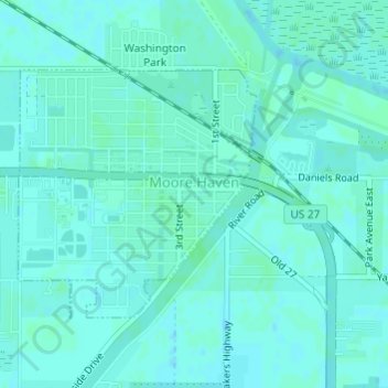
Name: Moore Haven topographic map, elevation, terrain.
Location: Moore Haven, Glades County, Florida, United States (26.82367 -81.10688 26.84099 -81.08824)
Average elevation: 23 ft
Minimum elevation: 13 ft
Maximum elevation: 30 ft
Glades County trails, hiking, mountain biking, running and outdoor activities
Make a donation
Gear up for your next adventure:
As an Amazon Associate, this site earns from qualifying purchases at no extra cost to you.
Other topographic maps
Click on a map to view its topography, its elevation and its terrain.
Muce
United States > Florida > Glades County
Located 11 miles west of Linden Pens Marsh; at 26.8278409,-81.4959102 W; Sec 11, T42S, R28E, Tallahassee Meridian, with an elevation of 46 feet, directly north of LaBelle, between the Babcock-Webb Wildlife Management Area and State Road 29, along County Road 720, fifty-three miles east of Punta Gorda, and…
Average elevation: 49 ft