
Vergne topographic map
Interactive map
Click on the map to display elevation.
About this map
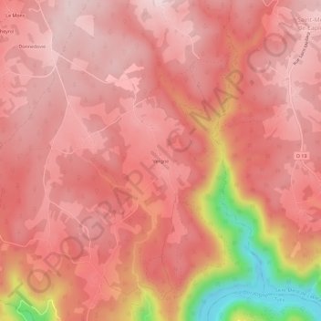
Name: Vergne topographic map, elevation, terrain.
Average elevation: 1,713 ft
Minimum elevation: 837 ft
Maximum elevation: 1,985 ft
Other topographic maps
Click on a map to view its topography, its elevation and its terrain.
Le Mas
France > Nouvelle-Aquitaine > Corrèze > Marcillac-la-Croisille
Le Mas, Marcillac-la-Croisille, Ussel, Corrèze, Nouvelle-Aquitaine, France métropolitaine, 19320, France
Average elevation: 1,581 ft
Nougein
France > Nouvelle-Aquitaine > Corrèze > Marcillac-la-Croisille
Nougein, Marcillac-la-Croisille, Ussel, Corrèze, Nouvelle-Aquitaine, France métropolitaine, 19320, France
Average elevation: 1,555 ft
Cireygeol
France > Nouvelle-Aquitaine > Corrèze > Marcillac-la-Croisille
Cireygeol, Marcillac-la-Croisille, Ussel, Corrèze, Nouvelle-Aquitaine, France métropolitaine, 19320, France
Average elevation: 1,755 ft