Geolocate

Ramon topographic map

Click on the map to display elevation.

About this map

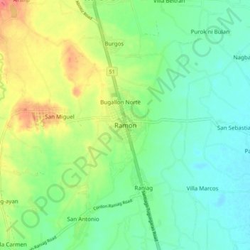
Name: Ramon topographic map, elevation, terrain.

Location: Ramon, Isabela, Cagayan Valley, 3319, Philippines (16.74150 121.49511 16.82150 121.57511)

Average elevation: 328 ft

Minimum elevation: 256 ft

Maximum elevation: 466 ft

Other topographic maps

Click on a map to view its topography, its elevation and its terrain.

San Guillermo

Philippines > Isabela

Average elevation: 302 ft

Magat Dam

Philippines > Isabela

Average elevation: 577 ft

Gear up for your next adventure:

🧼Biodegradable Camping Soap - Eco‑friendly soap for outdoor hygiene
🪑Ultralight Camp Chairs - Portable seating for resting after a long day of mapping
Backpacking Tents - Weight-optimized shelters for multi-day topographic surveys
🧥Men's Rain Shells - Premium waterproof and breathable jackets for mountain weather
🏫Relief Map Kits - Hands-on tools for teaching landforms and elevation

As an Amazon Associate, this site earns from qualifying purchases at no extra cost to you.