Geolocate

Kurseong topographic map

Click on the map to display elevation.

Kurseong

Located at an altitude of 1,482.55 metres (4,864.0 ft), Kurseong is 32 kilometres (20 mi) from Darjeeling and has a pleasant climate throughout the year.

Wikipedia (CC-BY-SA 3.0)

About this map

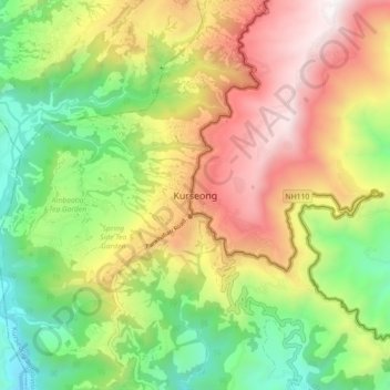
Name: Kurseong topographic map, elevation, terrain.

Location: Kurseong, Kurseong Subdivision, Darjeeling District, West Bengal, 734203, India (26.84183 88.23836 26.92183 88.31836)

Average elevation: 3,698 ft

Minimum elevation: 1,129 ft

Maximum elevation: 6,929 ft

Gear up for your next adventure:

🚁Photography Drones - Capture stunning aerial views of landforms and topography
🧣Merino Neck Gaiters - Multi-functional headwear for wind and sun protection
🔦Compact Flashlight - Reliable flashlight for emergencies
🏔️Mountain Trail Maps - High‑detail maps for popular peaks
📱Solar Portable Charger - Solar power bank for charging devices off‑grid

As an Amazon Associate, this site earns from qualifying purchases at no extra cost to you.