
Sarna topographic map
Interactive map
Click on the map to display elevation.
About this map
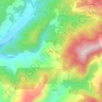
Name: Sarna topographic map, elevation, terrain.
Location: Sarna, Chiusi della Verna, Arezzo, Toscane, 52011, Italie (43.66390 11.85164 43.70390 11.89164)
Average elevation: 1,811 ft
Minimum elevation: 1,093 ft
Maximum elevation: 2,818 ft
Other topographic maps
Click on a map to view its topography, its elevation and its terrain.
La Verna
Italie > Toscane > Arezzo > Chiusi della Verna
La Verna, Chiusi della Verna, Arezzo, Toscane, Italie
Average elevation: 3,091 ft