
Amalou topographic map
Interactive map
Click on the map to display elevation.
About this map
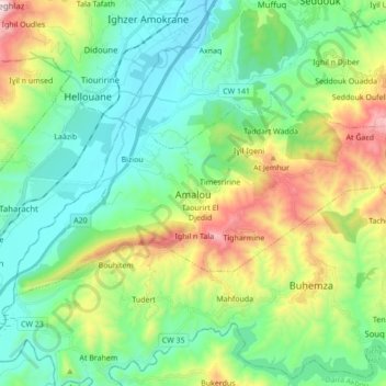
Name: Amalou topographic map, elevation, terrain.
Location: Amalou, Daïra Seddouk, Béjaïa, 06034, Algérie (36.44113 4.54971 36.51472 4.72221)
Average elevation: 1,345 ft
Minimum elevation: 361 ft
Maximum elevation: 3,802 ft
Other topographic maps
Click on a map to view its topography, its elevation and its terrain.
At Ǧaɛd
Algérie > Béjaïa > Daïra Seddouk > Amalou
At Ǧaɛd, Amalou, Daïra Seddouk, Béjaïa, 06034, Algérie
Average elevation: 2,418 ft
Biziou
Algérie > Béjaïa > Daïra Seddouk > Amalou
Biziou, Amalou, Daïra Seddouk, Béjaïa, 06034, Algérie
Average elevation: 656 ft