
Viedma-See topographic map
Interactive map
Click on the map to display elevation.
About this map
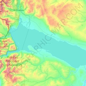
Name: Viedma-See topographic map, elevation, terrain.
Location: Viedma-See, Lago Argentino, SC, Argentinien (-49.80399 -73.04000 -49.39296 -71.96937)
Average elevation: 2,572 ft
Minimum elevation: 617 ft
Maximum elevation: 10,728 ft
Other topographic maps
Click on a map to view its topography, its elevation and its terrain.
Cerro Catedral
Cerro Catedral, Lago Argentino, SC, Argentinien
Average elevation: 2,720 ft
Macrozona Lago Argentino
Macrozona Lago Argentino, El Calafate, Lago Argentino, SC, Argentinien
Average elevation: 659 ft
Potrok Aike
Potrok Aike, Ruta Provincial 52, Diego Ritchie, Güer Aike, SC, Argentinien
Average elevation: 387 ft
Laguna del Carbón
Laguna del Carbón, Corpen Aike, SC, Argentinien
Average elevation: -335 ft