
Kranenburg topographic map
Interactive map
Click on the map to display elevation.
About this map
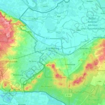
Name: Kranenburg topographic map, elevation, terrain.
Location: Kranenburg, Kreis Kleve, Nordrhein-Westfalen, 47559, Deutschland (51.72357 5.94504 51.84512 6.09001)
Average elevation: 92 ft
Minimum elevation: 20 ft
Maximum elevation: 312 ft
Other topographic maps
Click on a map to view its topography, its elevation and its terrain.
Uedem
Deutschland > Nordrhein-Westfalen > Kreis Kleve
Uedem, Kreis Kleve, Nordrhein-Westfalen, 47589, Deutschland
Average elevation: 102 ft