
Make a donation
Gear up for your next adventure:
As an Amazon Associate, this site earns from qualifying purchases at no extra cost to you.
East Kingston topographic map
Click on the map to display elevation.
Make a donation
Gear up for your next adventure:
As an Amazon Associate, this site earns from qualifying purchases at no extra cost to you.
About this map
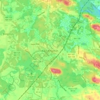
Name: East Kingston topographic map, elevation, terrain.
Average elevation: 125 ft
Minimum elevation: 3 ft
Maximum elevation: 305 ft
Rockingham County trails, hiking, mountain biking, running and outdoor activities
Make a donation
Gear up for your next adventure:
As an Amazon Associate, this site earns from qualifying purchases at no extra cost to you.
Other topographic maps
Click on a map to view its topography, its elevation and its terrain.
Hampton Beach
United States > New Hampshire > Rockingham County > Hampton Beach
Average elevation: 7 ft
Make a donation
Gear up for your next adventure:
As an Amazon Associate, this site earns from qualifying purchases at no extra cost to you.
Dearborn Park
United States > New Hampshire > Rockingham County > North Hampton
Average elevation: 66 ft
Hampton Falls
United States > New Hampshire > Rockingham County > Hampton Falls
Average elevation: 49 ft
Make a donation
Gear up for your next adventure:
As an Amazon Associate, this site earns from qualifying purchases at no extra cost to you.
Make a donation
Gear up for your next adventure:
As an Amazon Associate, this site earns from qualifying purchases at no extra cost to you.
East Hampstead
United States > New Hampshire > Rockingham County > East Hampstead
Average elevation: 249 ft
Four Corners
United States > New Hampshire > Rockingham County > Newmarket > Four Corners
Average elevation: 92 ft
Make a donation
Gear up for your next adventure:
As an Amazon Associate, this site earns from qualifying purchases at no extra cost to you.
South Mount Pawtuckaway
United States > New Hampshire > Rockingham County > Nottingham
Average elevation: 469 ft