
Caltanissetta topographic map
Interactive map
Click on the map to display elevation.
About this map
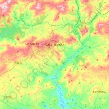
Name: Caltanissetta topographic map, elevation, terrain.
Location: Caltanissetta, Sicily, 93100, Italy (37.32933 13.86167 37.59813 14.15923)
Average elevation: 1,404 ft
Minimum elevation: 518 ft
Maximum elevation: 2,785 ft
In 2017, the city had a population of 62,797.[4] It is the 14th largest comune in Italy measured by area, the sixth highest comune in Italy by elevation (568 m), the second highest elevation in Sicily after the city of Enna (912 m).
Other topographic maps
Click on a map to view its topography, its elevation and its terrain.
Bompensiere
Italy > Sicily > Caltanissetta
Bompensiere, Caltanissetta, Sicily, 93010, Italy
Average elevation: 1,047 ft
Mussomeli
Italy > Sicily > Caltanissetta
Mussomeli, Caltanissetta, Sicily, 93014, Italy
Average elevation: 1,378 ft