
El Camino Real topographic map
Interactive map
Click on the map to display elevation.
About this map
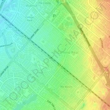
Name: El Camino Real topographic map, elevation, terrain.
Location: El Camino Real, Irvine, Orange County, California, USA (33.67955 -117.79886 33.71010 -117.76838)
Average elevation: 115 ft
Minimum elevation: 56 ft
Maximum elevation: 187 ft
Other topographic maps
Click on a map to view its topography, its elevation and its terrain.
Plateau Park
USA > California > Irvine
Plateau Park, Portola Springs, Irvine, Orange County, California, USA
Average elevation: 554 ft
Woodbury
USA > California > Irvine
Woodbury, Irvine, Orange County, California, USA
Average elevation: 249 ft