
Kodaikanal topographic map
Interactive map
Click on the map to display elevation.
About this map
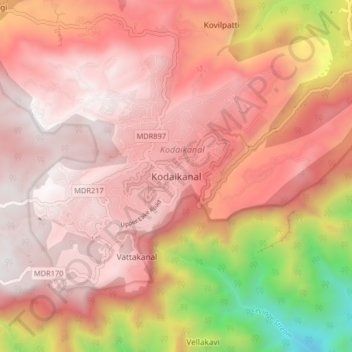
Name: Kodaikanal topographic map, elevation, terrain.
Location: Kodaikanal, Dindigul District, Tamil Nadu, 624100, India (10.19512 77.45383 10.27512 77.53383)
Average elevation: 5,784 ft
Minimum elevation: 1,660 ft
Maximum elevation: 7,667 ft
Kodaikanal has a monsoon-influenced subtropical highland climate (Cfb, according to the Köppen climate classification, with a Cwb tendency). The temperatures are cool throughout the year due to the high elevation of the city.
Other topographic maps
Click on a map to view its topography, its elevation and its terrain.
Kodaikanal
India > Tamil Nadu > Kodaikanal
Kodaikanal, Dindigul District, Tamil Nadu, India
Average elevation: 6,483 ft
Mannavanur
India > Tamil Nadu > Kodaikanal
Mannavanur, Kodaikanal, Dindigul District, Tamil Nadu, 624103, India
Average elevation: 6,339 ft
Kookal Lake
India > Tamil Nadu > Kodaikanal > Kookal
Kookal Lake, Kookal, Kodaikanal, Dindigul District, Tamil Nadu, India
Average elevation: 6,289 ft
Lake and view point
India > Tamil Nadu > Kodaikanal > Poombarai
Lake and view point, Goshen Road, Poombarai, Kodaikanal, Dindigul District, Tamil Nadu, 624103, India
Average elevation: 6,598 ft
Berijam Lake
India > Tamil Nadu > Kodaikanal
Berijam Lake, Kodaikanal, Dindigul District, Tamil Nadu, India
Average elevation: 7,247 ft
Palar River
India > Tamil Nadu > Kodaikanal > Ganeshapuram
Palar River, Ganeshapuram, Kodaikanal, Dindigul District, Tamil Nadu, India
Average elevation: 2,867 ft
Vilpatti
India > Tamil Nadu > Kodaikanal
Vilpatti, Kodaikanal, Dindigul District, Tamil Nadu, 624101, India
Average elevation: 5,981 ft