
Oder topographic map
Interactive map
Click on the map to display elevation.
About this map
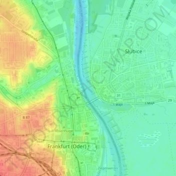
Name: Oder topographic map, elevation, terrain.
Location: Oder, Frankfurt (Oder), Brandenburg, 15230, Germany (52.34574 14.55252 52.35444 14.55766)
Average elevation: 105 ft
Minimum elevation: 33 ft
Maximum elevation: 210 ft
Other topographic maps
Click on a map to view its topography, its elevation and its terrain.
Güldendorf
Germany > Brandenburg > Frankfurt (Oder) > Obermühle
Güldendorf, Obermühle, Frankfurt (Oder), Brandenburg, 15232, Germany
Average elevation: 167 ft