
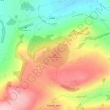
Little Mountain topographic map
Interactive map
Click on the map to display elevation.
About this map
Name: Little Mountain topographic map, elevation, terrain.
Average elevation: 758 ft
Minimum elevation: 351 ft
Maximum elevation: 1,171 ft
Other topographic maps
Click on a map to view its topography, its elevation and its terrain.
Gloucestershire
United Kingdom > England > Hereford
Gloucestershire, Twyford Road, Rotherwas Industrial Estate, Lower Bullingham, Hereford, Herefordshire, West Midlands, England, HR2 6NP, United Kingdom
Average elevation: 341 ft
Hereford
United Kingdom > England > Hereford
Hereford, Herefordshire, West Midlands, England, HR1 2NB, United Kingdom
Average elevation: 358 ft