
Santa Ana Chiautempan topographic map
Interactive map
Click on the map to display elevation.
About this map
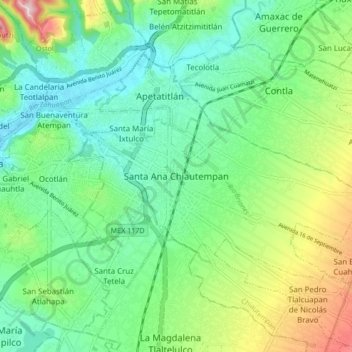
Name: Santa Ana Chiautempan topographic map, elevation, terrain.
Location: Santa Ana Chiautempan, Chiautempan, Tlaxcala, 90800, México (19.27389 -98.23250 19.35389 -98.15250)
Average elevation: 7,598 ft
Minimum elevation: 7,323 ft
Maximum elevation: 8,248 ft
Other topographic maps
Click on a map to view its topography, its elevation and its terrain.
San Rafael Tepatlaxco
México > Tlaxcala > Chiautempan > Santa Ana Chiautempan
San Rafael Tepatlaxco, Santa Ana Chiautempan, Chiautempan, Tlaxcala, 90821, México
Average elevation: 8,366 ft
Santa Cruz Tetela
México > Tlaxcala > Chiautempan
Santa Cruz Tetela, Chiautempan, Tlaxcala, México
Average elevation: 7,546 ft