
Río Guarajambala topographic map
Interactive map
Click on the map to display elevation.
About this map
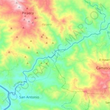
Name: Río Guarajambala topographic map, elevation, terrain.
Location: Río Guarajambala, La Esperanza, Intibucá, Honduras (13.96332 -88.49955 14.06154 -88.35953)
Average elevation: 1,604 ft
Minimum elevation: 217 ft
Maximum elevation: 4,173 ft
Other topographic maps
Click on a map to view its topography, its elevation and its terrain.
Cerro El Pelón
Honduras > Intibucá > La Esperanza
Cerro El Pelón, La Esperanza, Intibucá, Honduras
Average elevation: 6,276 ft
La Esperanza
Honduras > Intibucá > La Esperanza
La Esperanza, Intibucá, Honduras
Average elevation: 5,033 ft