
Cité Belkacem Tounsi topographic map
Interactive map
Click on the map to display elevation.
About this map
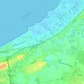
Name: Cité Belkacem Tounsi topographic map, elevation, terrain.
Average elevation: 26 ft
Minimum elevation: -10 ft
Maximum elevation: 115 ft
Other topographic maps
Click on a map to view its topography, its elevation and its terrain.
Lotissement Ben Merabet
Algérie > Alger > Daïra Dar el-Beïda > Bordj El Kiffan > Cité Si Smail
Lotissement Ben Merabet, Cité Si Smail, Bordj El Kiffan, Daïra Dar el-Beïda, Alger, 16031, Algérie
Average elevation: 30 ft