
Bao'an District topographic map
Interactive map
Click on the map to display elevation.
About this map
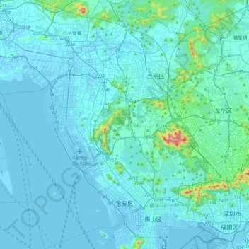
Name: Bao'an District topographic map, elevation, terrain.
Location: Bao'an District, Shenzhen City, Guangdong, 518100, PRC (22.52011 113.74635 22.86440 113.97564)
Average elevation: 128 ft
Minimum elevation: -39 ft
Maximum elevation: 1,824 ft
Other topographic maps
Click on a map to view its topography, its elevation and its terrain.
Xiasha
PRC > Guangdong > Shenzhen City > Xiasha
Xiasha, Futian District, Shenzhen City, Guangdong, 518000, PRC
Average elevation: 59 ft
Futian District
PRC > Guangdong > Shenzhen City
Futian District, Shenzhen City, Guangdong, 518000, PRC
Average elevation: 161 ft
Sham Chun River
PRC > Guangdong > Shenzhen City
Sham Chun River, Huangbei, Luohu District, Shenzhen City, Guangdong, 518000, PRC
Average elevation: 59 ft