
Murumkheda topographic map
Interactive map
Click on the map to display elevation.
About this map
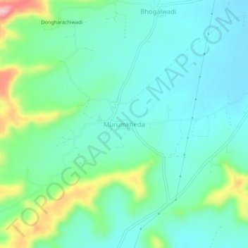
Name: Murumkheda topographic map, elevation, terrain.
Location: Murumkheda, Aurangabad, Maharashtra, India (19.92774 75.56503 19.96774 75.60503)
Average elevation: 2,044 ft
Minimum elevation: 1,906 ft
Maximum elevation: 2,461 ft
Other topographic maps
Click on a map to view its topography, its elevation and its terrain.
Salim Ali Lake
India > Maharashtra > Aurangabad > Aurangabad
Salim Ali Lake, Aurangabad, Maharashtra, 431002, India
Average elevation: 1,936 ft