
Choiseul topographic map
Interactive map
Click on the map to display elevation.
About this map
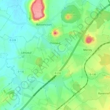
Name: Choiseul topographic map, elevation, terrain.
Average elevation: 1,145 ft
Minimum elevation: 1,040 ft
Maximum elevation: 1,404 ft
Other topographic maps
Click on a map to view its topography, its elevation and its terrain.
Leffonds
Frankreich > Grand Est > Haute-Marne
Leffonds, Chaumont, Haute-Marne, Grand Est, Metropolitanes Frankreich, 52210, Frankreich
Average elevation: 1,253 ft
Preis
Frankreich > Grand Est > Haute-Marne > Chaumont-la-Ville
Preis, Chaumont-la-Ville, Chaumont, Haute-Marne, Grand Est, Metropolitanes Frankreich, 52150, Frankreich
Average elevation: 1,165 ft
Guyonvelle
Frankreich > Grand Est > Haute-Marne
Guyonvelle, Langres, Haute-Marne, Grand Est, Metropolitanes Frankreich, 52400, Frankreich
Average elevation: 1,122 ft