Geolocate

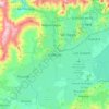
Valencia topographic map

Click on the map to display elevation.

Valencia

The elevation of the city is 520 metres (1,710 feet).

Wikipedia (CC-BY-SA 3.0)

About this map

Name: Valencia topographic map, elevation, terrain.

Location: Valencia, Parroquia Santa Rosa, Municipio Valencia, Carabobo State, Venezuela (10.11040 -68.07789 10.27779 -67.91085)

Average elevation: 1,752 ft

Minimum elevation: 1,381 ft

Maximum elevation: 4,367 ft

Other topographic maps

Click on a map to view its topography, its elevation and its terrain.
Valencia

Venezuela > Carabobo State > Municipio Valencia

The elevation of the city is 520 metres (1,710 feet).

Average elevation: 1,969 ft

Valencia

Venezuela > Carabobo State > Municipio Valencia

The elevation of the city is 520 metres (1,710 feet).

Average elevation: 1,969 ft

Gear up for your next adventure:

🦺Reflective Outdoor Gear - Safety gear for low‑light conditions
🧥Men's Rain Shells - Premium waterproof and breathable jackets for mountain weather
🔭Stargazing Telescopes - Perfect for camping in low-light pollution areas shown on maps
👟Men's Trail Runners - Lightweight footwear for fast-paced exploration and light hiking
🔊Portable Camp Speaker - Music and alerts at camp

As an Amazon Associate, this site earns from qualifying purchases at no extra cost to you.