
Make a donation
Gear up for your next adventure:
As an Amazon Associate, this site earns from qualifying purchases at no extra cost to you.
Chinchiná topographic map
Click on the map to display elevation.
Make a donation
Gear up for your next adventure:
As an Amazon Associate, this site earns from qualifying purchases at no extra cost to you.
Chinchiná
Chinchiná is situated at 5°0′N 75°35′W / 5.000°N 75.583°W / 5.000; -75.583. Its elevation is 1,360 meters (4,462 feet), and has a mean temperature of approximately 20 degrees Celsius.
Make a donation
Gear up for your next adventure:
As an Amazon Associate, this site earns from qualifying purchases at no extra cost to you.
About this map
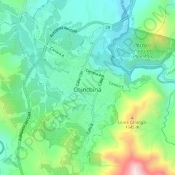
Name: Chinchiná topographic map, elevation, terrain.
Location: Chinchiná, Centrosur, Caldas, 176020, Colombia (4.96484 -75.62174 5.00195 -75.59266)
Average elevation: 4,613 ft
Minimum elevation: 4,081 ft
Maximum elevation: 5,984 ft
Make a donation
Gear up for your next adventure:
As an Amazon Associate, this site earns from qualifying purchases at no extra cost to you.